Partner: Naturhistorisches Museum Wien, Natural History Museum Vienna (NHMW)

Use Case objective
Use Case 5 aims to assess and provide an alternative approach to the European habitat classification system (EUNIS) by integrating vegetation species occurrence data with Earth Observation information to predict spatial distributions of European habitats.
Currently, the official European habitat classification system is primarily built on expert knowledge, with distribution maps derived from vegetation survey data. This approach overlooks valuable sources such as museum collections and citizen science records, which could enhance the accuracy and robustness of habitat distribution models. To address this gap, UC5 combines occurrence data from citizen science projects, herbarium collections, and vegetation surveys—available in open databases like Global Biodiversity Information Facility (GBIF)—with topographic and climatic variables through ensemble machine learning techniques.
Solutions and possible applications
UC5 developed a comprehensive R-based pipeline that integrates cleaned GBIF occurrence records with Earth Observation–derived topographic and climatic predictors to generate refined species distribution models at two spatial resolutions, 1 km (Europe area) and 100 m (Alps area). The ensemble approach combines GAM, GLM, and RF models, evaluated using TSS values, and includes procedures for generating pseudo-absences, validating results with the EVA database, and comparing outputs against official EUNIS probability maps.
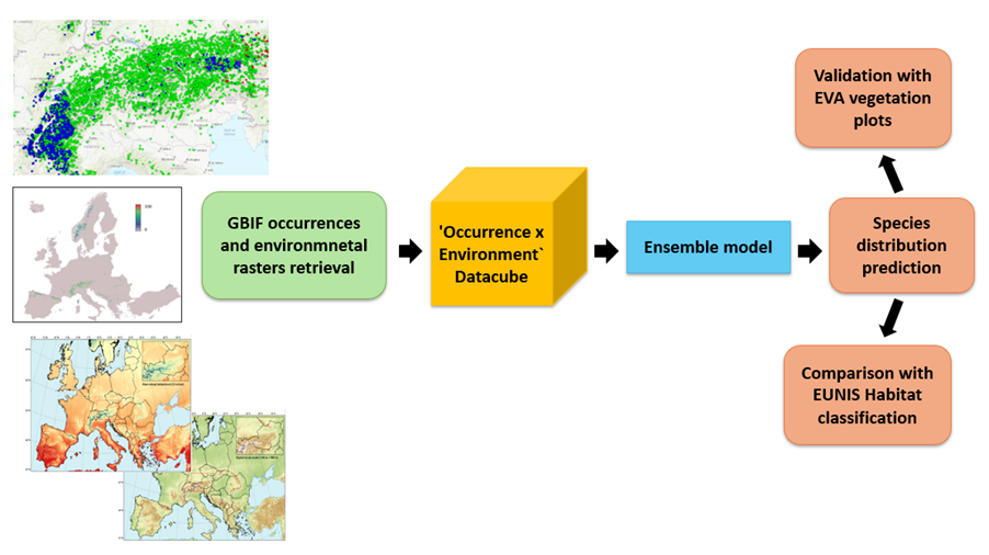
Overview of the Use Case 5 pipeline
The initial implementation focused on the distribution of the diagnostic species of the EUNIS habitat S22 ‘Alpine and subalpine ericoid heath’, but the methodology is fully scalable to other habitats across Europe.
The resulting species distribution maps reveal discrepancies and alignments with official classifications, offering new insights into habitat mapping accuracy and opportunities for more dynamic, evidence-based approaches.
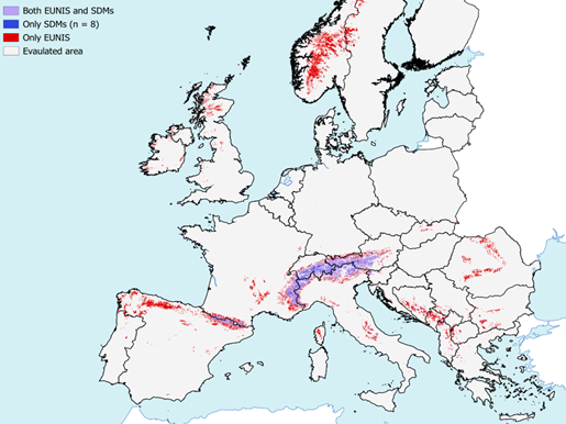
Visual comparison of the EUNIS distribution map and the UC5 species prediction map for the habitat S22, at 1 km resolution.
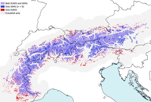
Visual comparison of the EUNIS distribution map and the UC5 species prediction map for the habitat S22, at 100 m resolution.
The outcomes support conservation strategies, optimise sampling design, and highlight ecologically significant areas for museum collections and biodiversity monitoring. UC5 also demonstrates the added value of citizen science and herbarium records when integrated with modern modelling techniques.
All outputs—species range maps and the reusable modelling pipeline (R scripts)—are FAIR-compliant, ensuring transparency, reproducibility, and practical uptake by researchers, policymakers, and practitioners working on habitat classification, monitoring, and conservation planning.
Resources and further documentation
UC5 has been implemented on the FAIRiCUBE Hub, ensuring transparent workflows and reproducibility. A dedicated section in the FAIRiCUBE Knowledge Base provides detailed documentation of the research questions, modelling pipeline, data processing, and evaluation methods. All resources, including open-source code and processed datasets, are linked for reuse and adaptation across contexts.
Further links to UC5 documentation:
- Read more about UC5 in the FAIRiCUBE Knowledge Base
- Find the scripts and datasets in the UC5 GitHub repository
- Find the interactive story map of the Use Case here UC5 Storytelling